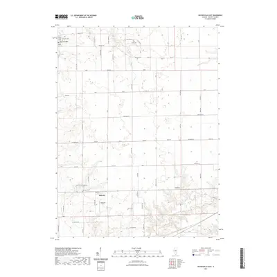
2021 Map of Waynesville East
USGS Topo · Published 2021About this map
Waynesville anchors the northwest corner of this DeWitt County landscape, where the prairie transitions into the drainage basins of Rock Cr and Tenmile Cr. The settlement pattern follows a rigid grid of rural routes like Kickapoo Rd and Tabor Rd, occasionally interrupted by small family or community burial grounds including Rock Creek Cem and Barnett Cem. Near the center of the sheet, Hallsville serves as a local hub, situated just north of the Hooterville Airport. The southern portion of the map is defined by the larger water bodies of Gibson Lakes, while the eastern edge is marked by the small community of Jenkins. This 2021 survey illustrates a modern agricultural landscape that maintains the precise land divisions and small-town footprints established in the nineteenth century, preserving the locations of historical sites such as McClimans Cem and Evergreen Cem.
Find a feature on this map
71 named features on this map. Tap any name to fly to it.
Don’t see what you’re looking for? This feature index may not catch every label — zoom into the map to look around manually.
Map Details
Editions of this 2021 Waynesville East Map
This is the sole edition of this map. No revisions or reprints were ever made.
Other maps of this area

1949 · Mc Lean
USGS Topo · 1:62,500

1951 · McLean
USGS Topo · 1:62,500

1951 · Le Roy
USGS Topo · 1:62,500

1957 · Kenney
USGS Topo · 1:62,500

1957 · Maroa
USGS Topo · 1:62,500

1958 · Peoria
USGS Topo · 1:250,000

1961 · Peoria
USGS Topo · 1:250,000

1963 · Peoria
USGS Topo · 1:250,000
1979 · Maroa
USGS Topo · 1:24,000
1979 · Clinton
USGS Topo · 1:24,000