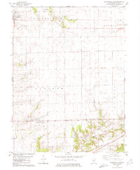
1980 Map of Waynesville East
USGS Topo · Published 1980About this map
Waynesville anchors the northwestern corner of this central Illinois landscape, where the prairie transitions into the drainage basins of Rock Creek and Tenmile Creek. This 1980 survey illustrates the organized township structure typical of De Witt County, with Waynesville, Wapella, and Barnett townships clearly defined by surveyed section lines. The Illinois Central Gulf railroad cuts a diagonal path across the southern territory, serving the small community of Hallsville. For those tracing local family history, the map is remarkably dense with rural burial grounds, including Evergreen Cem, Rock Creek Cem, and Barnett Cem, alongside several family-named landmarks such as McClimans Cem and the Holt Landing Strip. The southern edge features the waters of Gibson Lakes and the small crossing at Ford, showing a landscape defined by both agriculture and the intricate network of local drainages.
Find a feature on this map
21 named features on this map. Tap any name to fly to it.
Don’t see what you’re looking for? This feature index may not catch every label — zoom into the map to look around manually.
Map Details
Editions of this 1980 Waynesville East Map
This is the sole edition of this map. No revisions or reprints were ever made.
Other maps of this area

1949 · Mc Lean
USGS Topo · 1:62,500

1951 · McLean
USGS Topo · 1:62,500

1951 · Le Roy
USGS Topo · 1:62,500

1957 · Kenney
USGS Topo · 1:62,500

1957 · Maroa
USGS Topo · 1:62,500

1958 · Peoria
USGS Topo · 1:250,000

1961 · Peoria
USGS Topo · 1:250,000

1963 · Peoria
USGS Topo · 1:250,000
1979 · Maroa
USGS Topo · 1:24,000
1979 · Clinton
USGS Topo · 1:24,000