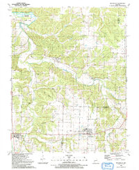
1991 Map of Weaubleau
USGS Topo · Published 1991About this map
The town of Weaubleau serves as the focal point of this rural Missouri landscape at the border of St. Clair and Hickory Counties. The terrain is defined by the winding course of Weaubleau Creek and its many tributaries, including Little Weaubleau Creek and the southern South Fork Big Hollow Creek. A significant piece of local transportation history is visible in the Old Railroad Grade, which cuts through the small settlement of Gerster in the northern portion of the quadrangle. Local genealogy is anchored by landmarks such as the Robinson Cem and the Kings Prairie Ch. To the west, the community of Collins stands near the headwaters of the E Br Coon Cr, while recreational and natural sites like the Kings Prairie State Access and Gum Spring highlight the area's water resources.
Find a feature on this map
29 named features on this map. Tap any name to fly to it.
Don’t see what you’re looking for? This feature index may not catch every label — zoom into the map to look around manually.
Map Details
Editions of this 1991 Weaubleau Map
This is the sole edition of this map. No revisions or reprints were ever made.
Other maps of this area

1884 · Bolivar
USGS Topo · 1:125,000

1886 · Stockton
USGS Topo · 1:125,000

1887 · Clinton
USGS Topo · 1:125,000

1887 · Warsaw
USGS Topo · 1:125,000

1892 · Bolivar
USGS Topo · 1:125,000

1894 · Warsaw
USGS Topo · 1:125,000

1894 · Clinton
USGS Topo · 1:125,000

1938 · Vista
USGS Topo · 1:24,000

1939 · Osceola
USGS Topo · 1:24,000

1939 · Arnica
USGS Topo · 1:24,000