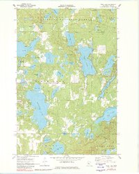
1970 Map of Webb Lake
USGS Topo · Published 1983About this map
Chippewa National Forest dominates this northern landscape, where a dense network of glacial lakes defines the geography. The area between Webb Lake and Pleasant Lake showcases a transition toward recreational development, evidenced by a Golf Course and a prominent Radio Tower (KNMT-TV) standing near Long Lake. The map details a complex hydrologic system including smaller basins like Larson Lake, Stony Lake, and Blueberry Lake, many of which are connected by narrow channels or seasonal wetlands. While much of the land remains under federal management or within the Birch Lake and Ponto Lake townships, human activity is visible in scattered Gravel Pit sites and established public access points. This 1970 snapshot preserves the lake-country character of Cass County before further shoreline modernization, tracing the intricate boundaries of the Forest Boundary.
Find a feature on this map
50 named features on this map. Tap any name to fly to it.
Don’t see what you’re looking for? This feature index may not catch every label — zoom into the map to look around manually.
Map Details
Editions of this 1970 Webb Lake Map
2 editions found

Other maps of this area

1953 · Brainerd
USGS Topo · 1:250,000

1954 · Bemidji
USGS Topo · 1:250,000

1957 · Brainerd
USGS Topo · 1:250,000

1957 · Bemidji
USGS Topo · 1:250,000

1958 · Bemidji
USGS Topo · 1:250,000

1958 · Brainerd
USGS Topo · 1:250,000

1965 · Brainerd
USGS Topo · 1:250,000

1970 · Backus
USGS Topo · 1:24,000

1970 · Hackensack
USGS Topo · 1:24,000
1970 · Mildred
USGS Topo · 1:24,000