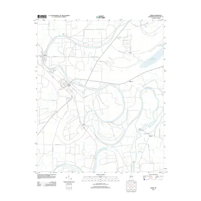
2012 Map of Webb
USGS Topo · Published 2012About this map
The Tallahatchie River and Lower Quiver River define this Delta landscape, where water and agriculture dictate the layout of small Mississippi towns. Centered on the town of Webb, the area shows a distinct grid pattern alongside the neighboring settlement of Sumner, which is flanked by the Woodlawn Cem. The winding course of the river creates numerous oxbows and landings, such as Sharkeys Landing and Arbin Landing, which historically served as vital points for commerce and transport. The map details a network of rural roads like Sumner-Miss 321 Rd and Oil Mill Rd that connect outlying communities like Albin and Mikoma. Large bodies of water, including Buzzard Bayou Lake and Swan Lake, suggest a fertile environment with complex drainage patterns characteristic of this part of Tallahatchie County.
Find a feature on this map
71 named features on this map. Tap any name to fly to it.
Don’t see what you’re looking for? This feature index may not catch every label — zoom into the map to look around manually.
Map Details
Editions of this 2012 Webb Map
This is the sole edition of this map. No revisions or reprints were ever made.
Other maps of this area

1931 · Sumner
USGS Topo · 1:48,000

1932 · Philipp
USGS Topo · 1:48,000

1932 · Tutwiler
USGS Topo · 1:48,000

1935 · Crowder
USGS Topo · 1:62,500

1935 · Sumner
USGS Topo · 1:62,500

1935 · Tutwiler
USGS Topo · 1:62,500

1935 · Philipp
USGS Topo · 1:62,500

1939 · Sumner
USGS Topo · 1:62,500

1939 · Crowder
USGS Topo · 1:62,500

1939 · Philipp
USGS Topo · 1:62,500