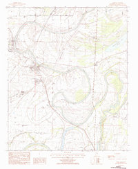
1983 Map of Webb
USGS Topo · Published 1984About this map
Sumner and Webb serve as the primary population centers in this Delta landscape, linked by the Illinois Central Gulf railroad and the meandering path of Cassidy Bayou. The map illustrates a region deeply defined by its water management and agricultural heritage, featuring extensive levee systems and a network of drainage including Snow Brake and the Tallahatchie River. Numerous rural spiritual and educational landmarks are visible, such as Brooklyn Ch, Old Bethel Ch, and the Sumner West District High Sch. The presence of large-scale landholdings like Rainbow Plantation and smaller settlements like Sharkey and Albin suggests the established cotton-growing economy of the early 1980s. Local aviators utilized the Falls Landing Strip and Twilight Landing Strip, reflecting the rural transportation patterns of Tallahatchie County before modern consolidation.
Find a feature on this map
37 named features on this map. Tap any name to fly to it.
Don’t see what you’re looking for? This feature index may not catch every label — zoom into the map to look around manually.
Map Details
Editions of this 1983 Webb Map
This is the sole edition of this map. No revisions or reprints were ever made.
Other maps of this area

1931 · Sumner
USGS Topo · 1:48,000

1932 · Philipp
USGS Topo · 1:48,000

1932 · Tutwiler
USGS Topo · 1:48,000

1935 · Crowder
USGS Topo · 1:62,500

1935 · Sumner
USGS Topo · 1:62,500

1935 · Tutwiler
USGS Topo · 1:62,500

1935 · Philipp
USGS Topo · 1:62,500

1939 · Sumner
USGS Topo · 1:62,500

1939 · Crowder
USGS Topo · 1:62,500

1939 · Philipp
USGS Topo · 1:62,500