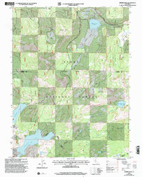
2000 Map of Webber Peak
USGS Topo · Published 2003About this map
Webber Peak towers over the high alpine terrain of Tahoe National Forest, where the headwaters of several major watersheds converge. This landscape is defined by its glaciated basins and meadows, including Coppins Meadow and Perazzo Meadows, which feed the Little Truckee River and the Middle Yuba River. The historical importance of this corridor is evident in the presence of Henness Pass Road, a significant 19th-century immigrant route that traverses the northern sections. In the south, the Anderson Mine and various unlabeled mine sites suggest the area's prospecting history, while the modern recreational character is established through the Pacific Crest National Scenic Trail and Lola Montez Trail. Large water bodies like Fordyce Lake and Webber Lake are central features, alongside smaller alpine basins such as White Rock Lake and Sand Ridge Lake.
Find a feature on this map
40 named features on this map. Tap any name to fly to it.
Don’t see what you’re looking for? This feature index may not catch every label — zoom into the map to look around manually.
Map Details
Editions of this 2000 Webber Peak Map
This is the sole edition of this map. No revisions or reprints were ever made.
Other maps of this area

1890 · Sierraville
USGS Topo · 1:125,000

1891 · Downieville
USGS Topo · 1:125,000

1891 · Colfax
USGS Topo · 1:125,000

1891 · Truckee
USGS Topo · 1:125,000

1892 · Sierraville
USGS Topo · 1:125,000

1892 · Colfax
USGS Topo · 1:125,000

1893 · Truckee
USGS Topo · 1:125,000

1893 · Downieville
USGS Topo · 1:125,000

1894 · Colfax
USGS Topo · 1:125,000

1894 · Sierraville
USGS Topo · 1:125,000