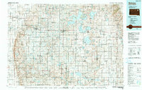
1985 Map of Webster
USGS Topo · Published 1989About this map
The Sisseton Wahpeton Indian Reservation dominates the eastern landscape of this 1980s-era survey, revealing a region defined by its complex glacial hydrology. A network of significant water bodies, including Waubay Lake, Enemy Swim Lake, and Bitter Lake, supports the Waubay National Wildlife Refuge, which provides a protected core for the area's natural environment. The Burlington Northern railroad serves as the primary industrial corridor, connecting established prairie towns such as Webster, Bristol, and Waubay. Transportation and commerce are further evidenced by the Webster Municipal Airport and the smaller Henricks Landing Strip. This map captures a moment of modern agricultural and tribal land management, showing how the rural road grid navigates around the numerous sloughs and lakes like Campbell Slough and Pearson Slough that punctuate the northeastern South Dakota plains.
Find a feature on this map
106 named features on this map. Tap any name to fly to it.
Don’t see what you’re looking for? This feature index may not catch every label — zoom into the map to look around manually.
Map Details
Editions of this 1985 Webster Map
2 editions found
Other maps of this area

1894 · Conde
USGS Topo · 1:62,500

1895 · Byron
USGS Topo · 1:125,000

1895 · Aberdeen
USGS Topo · 1:125,000

1896 · Columbia
USGS Topo · 1:125,000

1916 · Peever
USGS Topo · 1:62,500

1918 · Peever
USGS Topo · 1:62,500

1952 · Huffton
USGS Topo · 1:24,000

1953 · Milbank
USGS Topo · 1:250,000

1953 · Huron
USGS Topo · 1:250,000

1953 · Watertown
USGS Topo · 1:250,000