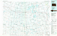
1985 Map of Webster
USGS Topo · Published 1985About this map
Webster serves as a central hub on this 1985 planimetric study, surrounded by a complex network of glacial wetlands and agricultural lands. The landscape is heavily defined by conservation efforts, with numerous State Game Production Area and National Waterfowl Production Area parcels interspersed between small farming communities. To the east, the Lake Traverse Indian Reservation spans the border of Day Co and Roberts Co, emphasizing the region's diverse jurisdictional history.
Find a feature on this map
85 named features on this map. Tap any name to fly to it.
Don’t see what you’re looking for? This feature index may not catch every label — zoom into the map to look around manually.
Map Details
Editions of this 1985 Webster Map
2 editions found
Other maps of this area

1894 · Conde
USGS Topo · 1:62,500

1895 · Byron
USGS Topo · 1:125,000

1895 · Aberdeen
USGS Topo · 1:125,000

1896 · Columbia
USGS Topo · 1:125,000

1916 · Peever
USGS Topo · 1:62,500

1918 · Peever
USGS Topo · 1:62,500

1952 · Huffton
USGS Topo · 1:24,000

1953 · Milbank
USGS Topo · 1:250,000

1953 · Huron
USGS Topo · 1:250,000

1953 · Watertown
USGS Topo · 1:250,000