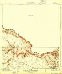
1919 Map of Weeden
USGS Topo · Published 1932About this map
Spring Creek meanders along the Montgomery Co Harris Co Boundary Line, carving a deep, complex drainage system through the landscape. This 1919 survey, based on 1916 fieldwork and reprinted in 1932, highlights a region transitioning toward industrial and transportation connectivity. The Houston and East Texas Railway and the Bender Railroad converge near the growing settlement of Humble, indicating the era's rail-dependent economy. Cultural markers of early 20th-century Texas life are preserved here, including the Tullus Cemetery and local education centers like Pine Chapel School and School No 29. The map provides an exceptionally detailed look at the relief around Wild Cow Gulch and Cypress Creek, though a large portion of the northern half remains labeled as a Preliminary Edition Unsurveyed Area, reflecting the ongoing nature of topographic mapping in this period.
Find a feature on this map
17 named features on this map. Tap any name to fly to it.
Don’t see what you’re looking for? This feature index may not catch every label — zoom into the map to look around manually.
Map Details
Editions of this 1919 Weeden Map
2 editions found
Other maps of this area

1916 · Aldine
USGS Topo · 1:24,000

1916 · Harmaston
USGS Topo · 1:24,000

1916 · Moonshine Hill
USGS Topo · 1:24,000

1916 · Humble
USGS Topo · 1:24,000

1916 · Spring
USGS Topo · 1:24,000

1919 · Aldine
USGS Topo · 1:31,680

1919 · Humble
USGS Topo · 1:31,680

1919 · Weeden
USGS Topo · 1:31,680

1920 · Spring
USGS Topo · 1:31,680

1920 · Harmaston
USGS Topo · 1:31,680