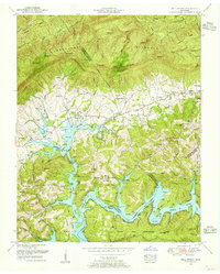
1952 Map of Well Spring
USGS Topo · Published 1955About this map
The Powell River valley and its transition into the Cumberland Mountain range define this 1952 landscape, where the rising waters of Norris Lake have altered the low-lying terrain. Centered on the settlement of Well Spring and the Speedwell Post Office, the map reveals a dense network of family-named cemeteries and rural institutions, such as Speedwell Academy and Flat Hollow Church. The Norris Reservation Boundary and the Chuck Swan Management Area dominate the southern portion, marking a shift from private farmsteads to public conservation. Higher elevations to the north include landmarks like McLean Rock on the Tennessee Valley Divide, offering a view of the intricate creek systems like Tackett Creek and Davis Creek that drain into the reservoir below.
Find a feature on this map
94 named features on this map. Tap any name to fly to it.
Don’t see what you’re looking for? This feature index may not catch every label — zoom into the map to look around manually.
Map Details
Editions of this 1952 Well Spring Map
4 editions found
Other maps of this area

1886 · Cumberland Gap
USGS Topo · 1:125,000

1888 · Cumberland Gap
USGS Topo · 1:125,000

1890 · Williamsburg
USGS Topo · 1:125,000

1891 · Cumberland Gap
USGS Topo · 1:125,000

1893 · Briceville
USGS Topo · 1:125,000

1894 · Williamsburg
USGS Topo · 1:125,000

1895 · Briceville
USGS Topo · 1:125,000

1896 · Briceville
USGS Topo · 1:125,000

1897 · Maynardville
USGS Topo · 1:125,000

1900 · Maynardville
USGS Topo · 1:125,000