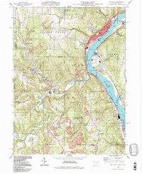
1994 Map of Wellsville
USGS Topo · Published 1998About this map
The Ohio River valley at the junction of Ohio and West Virginia reveals a landscape deeply defined by its industrial and topographical variety. In the river’s sweeping bend, the town of Wellsville sits as a primary hub, characterized by its dense street grid including Main St and Commerce St. The surrounding terrain is marked by numerous strip mines and quarries, reflecting the extractive history of the region. Local heritage is preserved in several rural religious and burial sites such as Oak Ridge Ch, Spring Hill Cem, and Cuppy Cem. Along the winding course of Yellow Creek, smaller settlements like Hammondsville and Irondale are connected by the Conrail line. The southern portion of the map is dominated by the New Cumberland Lock and Dam, while the Brush Creek State Wildlife Area provides a significant contrast of preserved natural space amidst the active resource extraction zones.
Find a feature on this map
73 named features on this map. Tap any name to fly to it.
Don’t see what you’re looking for? This feature index may not catch every label — zoom into the map to look around manually.
Map Details
Editions of this 1994 Wellsville Map
This is the sole edition of this map. No revisions or reprints were ever made.
Other maps of this area

1901 · Cadiz
USGS Topo · 1:62,500

1903 · Cadiz
USGS Topo · 1:62,500

1904 · Wellsville
USGS Topo · 1:62,500

1904 · Steubenville
USGS Topo · 1:62,500

1905 · Salineville
USGS Topo · 1:62,500

1935 · Steubenville
USGS Topo · 1:62,500

1937 · Wellsville
USGS Topo · 1:62,500

1942 · Steubenville
USGS Topo · 1:62,500

1944 · Wellsville
USGS Topo · 1:62,500

1951 · Canton
USGS Topo · 1:250,000