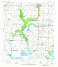
1955 Map of Welsh
USGS Topo · Published 1966About this map
The Lacassine National Wildlife Refuge dominates the southern landscape of this 1950s survey, illustrating a vast network of marshes and levees defined by the Mermentau River and Lake Arthur. This era captures Southwest Louisiana's dual reliance on rice cultivation and petroleum extraction, with the Southern Pacific railroad connecting established towns like Welsh and Lacassine to the broader regional economy. Away from the rail lines, the map reveals smaller settlements such as Hayes and Bell City, along with numerous family landmarks including Broussard Cem and Foreman Cem. The intricate system of man-made waterways, such as the Chene Canal and Niblett Canal, highlights the significant engineering required to manage the wetlands for both transportation and irrigation. Several active energy sites, including the Bon Air Oil Field and the South Bell City Gas Field, appear alongside industrial points like the Illinois Plant, marking the mid-century industrialization of the prairie.
Find a feature on this map
45 named features on this map. Tap any name to fly to it.
Don’t see what you’re looking for? This feature index may not catch every label — zoom into the map to look around manually.
Map Details
Editions of this 1955 Welsh Map
4 editions found
Other maps of this area

1932 · Lake Charles NE
USGS Topo · 1:31,680

1932 · Lake Charles SE
USGS Topo · 1:31,680

1934 · Lake Misere
USGS Topo · 1:24,000

1934 · Boudreaux Lake
USGS Topo · 1:24,000

1934 · Latania Lake
USGS Topo · 1:24,000

1935 · Lake Misere
USGS Topo · 1:31,680

1935 · Latania Lake
USGS Topo · 1:31,680

1935 · Boudreaux Lake
USGS Topo · 1:31,680

1942 · Lake Charles
USGS Topo · 1:62,500

1946 · Lacassine
USGS Topo · 1:31,680