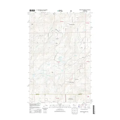
2014 Map of Wenatchee Heights
USGS Topo · Published 2014About this map
Wenatchee Heights and its surrounding plateau reveal an intricate network of highland water management south of the Columbia River valley. This 2014 survey details a landscape of specialized irrigation and ranching, where numerous small-scale water bodies like the Steffen Brothers Reservoir and Milo Wood Pond support the orchards and agricultural tracts of Stemilt Hill. The terrain rises sharply from the canyons to the north into the Wenatchee National Forest, with Jumpoff Ridge and Wheeler Hill defining the high-altitude topography. A quiet infrastructure of rural life is evident, from the Stemilt Hill Cem to the private Hoverhawk Ranch Airport. The mapping also tracks the transition into Kittitas County at the southern boundary, where the forest thickens and features such as Lily Lake and Rose Lake are situated amongst the headwaters of the Stemilt and Squilchuck drainages.
Find a feature on this map
101 named features on this map. Tap any name to fly to it.
Don’t see what you’re looking for? This feature index may not catch every label — zoom into the map to look around manually.
Map Details
Editions of this 2014 Wenatchee Heights Map
This is the sole edition of this map. No revisions or reprints were ever made.
Other maps of this area

1912 · Malaga
USGS Topo · 1:48,000

1913 · Wenatchee
USGS Topo · 1:62,500

1914 · Malaga
USGS Topo · 1:62,500

1915 · Wenatchee
USGS Topo · 1:62,500

1920 · Colockum Pass
USGS Topo · 1:125,000

1922 · Colockum Pass
USGS Topo · 1:125,000

1957 · Wenatchee
USGS Topo · 1:250,000

1966 · Rock Island
USGS Topo · 1:24,000

1966 · Wenatchee
USGS Topo · 1:24,000
1966 · Colockum Pass
USGS Topo · 1:24,000