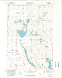
1973 Map of Wendell
USGS Topo · Published 1975About this map
Wendell serves as the primary settlement on this western Minnesota landscape, situated at the intersection of local roads and the Soo rail line. The surrounding prairie is defined by an extensive network of conservation lands, including the National Waterfowl Production Area and the Bergerud State Wildlife Management Area, which protect numerous small lakes and glacial depressions. The hydrology is centered on the Mustinka River and its accompanying Mustinka State Wildlife Management Area, as the waterway flows southwest toward Elbow Lake. A distinct Old Railroad Grade Line cuts across the southern townships, marking a former transportation corridor through Stony Brook and Elbow Lake townships. Genealogists will find the Trinity Cem located west of the Mustinka, while large water bodies like Lightning Lake and Sanford highlight the area's aquatic character.
Find a feature on this map
24 named features on this map. Tap any name to fly to it.
Don’t see what you’re looking for? This feature index may not catch every label — zoom into the map to look around manually.
Map Details
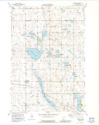
Editions of this 1973 Wendell Map
2 editions found
Other maps of this area

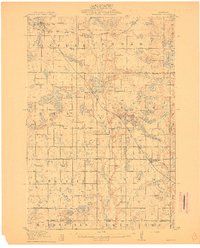
1910 · Wendell
USGS Topo · 1:62,500
1911 · Barrett
USGS Topo · 1:62,500

1911 · Herman
USGS Topo · 1:62,500

1913 · Ashby
USGS Topo · 1:62,500

1913 · Wendell
USGS Topo · 1:62,500

1953 · Milbank
USGS Topo · 1:250,000

1953 · Fargo
USGS Topo · 1:250,000

1953 · Brainerd
USGS Topo · 1:250,000

1953 · Saint Cloud
USGS Topo · 1:250,000

1956 · Fargo
USGS Topo · 1:250,000