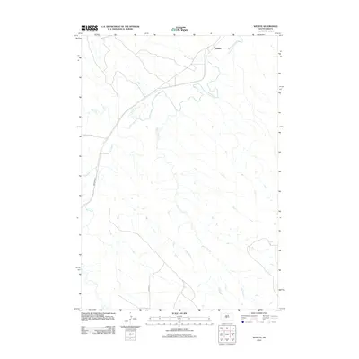
2012 Map of Wendte
USGS Topo · Published 2012About this map
The Bad River carves a winding path through this Stanley County landscape, creating a complex network of drainage systems including Deep Creek and Tomahawk Creek. The small settlement of Wendte sits at the northern edge of the map, positioned near where these tributaries meet the main river channel. This area is characterized by its high-density dendritic drainage patterns, with Herd Camp Creek and White Clay Creek reaching deep into the southern reaches of the quadrangle.
Find a feature on this map
11 named features on this map. Tap any name to fly to it.
Don’t see what you’re looking for? This feature index may not catch every label — zoom into the map to look around manually.
Map Details
Editions of this 2012 Wendte Map
This is the sole edition of this map. No revisions or reprints were ever made.
Other maps of this area

1937 · Oahe
USGS Topo · 1:62,500

1951 · Van Metre
USGS Topo · 1:24,000

1951 · Capa SE
USGS Topo · 1:24,000

1953 · Teton
USGS Topo · 1:24,000

1953 · Oahe SW
USGS Topo · 1:24,000

1953 · Wendte
USGS Topo · 1:24,000

1953 · Wendte NE
USGS Topo · 1:24,000

1954 · Pierre
USGS Topo · 1:250,000

1958 · Pierre
USGS Topo · 1:250,000
1972 · Wendte SE
USGS Topo · 1:24,000