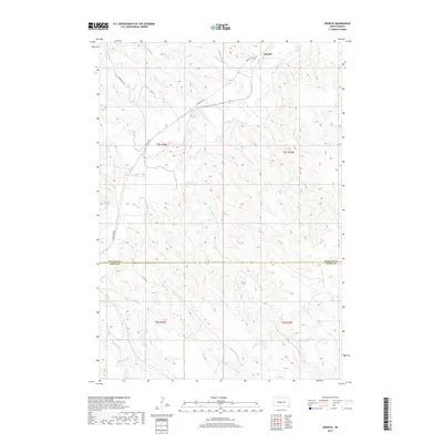
2017 Map of Wendte
USGS Topo · Published 2017About this map
Bad River meanders across the northern portion of this South Dakota landscape, defining the local geography around the small settlement of Wendte. The terrain is characterized by a dense network of drainage channels and creek beds, including Herd Camp Cr, Deep Cr, and Tomahawk Cr, which carve through the high prairie. The map illustrates a sparse rural infrastructure, where long-established section lines and roads like Bad River Rd and Bunkhouse Rd facilitate movement across the rolling plains. Spanning the Stanley County and Jones County boundary, the sheet captures the transition from the river valley to the southern uplands near White Clay Cr. This survey provides a clear view of the complex hydrology and grazing lands typical of the region's ranching economy in the early 21st century.
Find a feature on this map
16 named features on this map. Tap any name to fly to it.
Don’t see what you’re looking for? This feature index may not catch every label — zoom into the map to look around manually.
Map Details
Editions of this 2017 Wendte Map
This is the sole edition of this map. No revisions or reprints were ever made.
Other maps of this area

1937 · Oahe
USGS Topo · 1:62,500

1951 · Van Metre
USGS Topo · 1:24,000

1951 · Capa SE
USGS Topo · 1:24,000

1953 · Teton
USGS Topo · 1:24,000

1953 · Oahe SW
USGS Topo · 1:24,000

1953 · Wendte
USGS Topo · 1:24,000

1953 · Wendte NE
USGS Topo · 1:24,000

1954 · Pierre
USGS Topo · 1:250,000

1958 · Pierre
USGS Topo · 1:250,000
1972 · Wendte SE
USGS Topo · 1:24,000