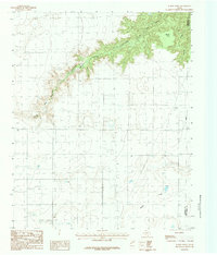
1984 Map of Wesley Point
USGS Topo · Published 1984About this map
South Cita Canyon carves a dramatic path through the High Plains along the border of Randall and Armstrong counties. This 1980s landscape is defined by the sharp contrast between the flat upland plains and the sudden erosion of the canyon floor, where South Cita Creek winds beneath the prominent overlook at Wesley Point. The map documents a sparsely settled ranching environment where the primary human footprint consists of numerous Wells scattered across the plateau. Drainage patterns are clearly marked by intermittent features like Curry Draw and Happy Draw, which feed into the larger canyon system. The survey captures the area just as modern topographical mapping techniques were being finalized for this portion of the Texas Panhandle, providing a precise record of the natural terrain and water resources.
Find a feature on this map
7 named features on this map. Tap any name to fly to it.
Don’t see what you’re looking for? This feature index may not catch every label — zoom into the map to look around manually.
Map Details
Editions of this 1984 Wesley Point Map
This is the sole edition of this map. No revisions or reprints were ever made.
Other maps of this area

1954 · Plainview
USGS Topo · 1:250,000

1956 · Fortress Cliff
USGS Topo · 1:24,000

1958 · Plainview
USGS Topo · 1:250,000

1960 · Canyon
USGS Topo · 1:62,500

1960 · Wayside
USGS Topo · 1:62,500

1965 · Happy
USGS Topo · 1:24,000

1969 · Jackson Hill
USGS Topo · 1:24,000

1969 · Tule Lake NW
USGS Topo · 1:24,000
1984 · Pony Flats
USGS Topo · 1:24,000
1984 · Wayside
USGS Topo · 1:24,000