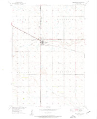
1950 Map of Wessington
USGS Topo · Published 1950About this map
Wessington serves as the focal point of this 1950 prairie landscape, situated precisely on the county line dividing Hand and Beadle Counties. The town's layout and economy are dictated by the Chicago and North Western railroad, which cuts a straight path through the territory. Outside the main settlement, the land is organized into the townships of Grand, Whiteside, Hulbert, and Wessington.
Find a feature on this map
16 named features on this map. Tap any name to fly to it.
Don’t see what you’re looking for? This feature index may not catch every label — zoom into the map to look around manually.
Map Details
Editions of this 1950 Wessington Map
3 editions found
Other maps of this area

1899 · Redfield
USGS Topo · 1:125,000

1949 · Vayland SE
USGS Topo · 1:24,000

1950 · Vayland
USGS Topo · 1:24,000

1950 · Wessington
USGS Topo · 1:24,000

1950 · Wessington NE
USGS Topo · 1:24,000

1951 · Wessington SE
USGS Topo · 1:24,000

1951 · Wessington SW
USGS Topo · 1:24,000

1951 · Vayland SE
USGS Topo · 1:24,000

1953 · Huron
USGS Topo · 1:250,000

1954 · Huron
USGS Topo · 1:250,000