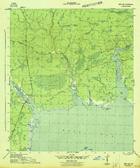
1944 Map of West Bay
USGS Topo · Published 1944About this map
West Bay serves as the focal point for this wartime survey by the Army Corps of Engineers, showing the northern reaches of the bay and its complex network of feeding tributaries. The landscape is dominated by dense hydrologic features, where Crooked Creek and Pigeon Creek wind through low-lying coastal terrain before emptying into the larger body of West Bay. The recently established route of the Intracoastal Waterway cuts a distinct path through the southern portion of the map, signaling the era's focus on maritime transport and defense logistics. Numerous family-named or descriptive points define the shoreline, including Walsonham Point and Breakfast Point. Away from the water, the map tracks several small branches such as Big Lily Branch and Kelly Branch, which drain the undeveloped interior during this period of Florida's history.
Find a feature on this map
25 named features on this map. Tap any name to fly to it.
Don’t see what you’re looking for? This feature index may not catch every label — zoom into the map to look around manually.
Map Details
Editions of this 1944 West Bay Map
4 editions found
Other maps of this area

1943 · Laguna Beach
USGS Topo · 1:31,680

1943 · Panama City
USGS Topo · 1:31,680

1943 · Panama City Beach
USGS Topo · 1:31,680

1943 · Seminole Hills
USGS Topo · 1:24,000

1943 · West Bay
USGS Topo · 1:24,000

1943 · Southport
USGS Topo · 1:24,000

1944 · Southport
USGS Topo · 1:24,000

1944 · Seminole Hills
USGS Topo · 1:31,680

1944 · West Bay
USGS Topo · 1:31,680

1944 · Crystal Lake
USGS Topo · 1:24,000