
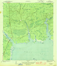
1944 Map of West Bay
USGS Topo · Published 1960About this map
The West Bay settlement and its surrounding wetlands are documented here in the early 1940s, showing a landscape defined by its intricate drainage into the larger bay. The northern reaches of the map are dominated by numerous named branches, including Pigeon Creek, Crooked Creek, and the curiously named Big Lily Belt, which feed into the coastal marsh system. This era's infrastructure is highlighted by the prominent path of the Intracoastal Waterway, which cuts through the southern landmass near Double Bayou.
Find a feature on this map
20 named features on this map. Tap any name to fly to it.
Don’t see what you’re looking for? This feature index may not catch every label — zoom into the map to look around manually.
Map Details
Editions of this 1944 West Bay Map
4 editions found
Historical Maps of Panama City Beach Through Time
135 maps found

1943 Beacon Beach
Bay County, FL

1943 Crooked Island
Bay County, FL

1943 Seminole Hills
Bay County, FL

1943 Southport
Bay County, FL

1943 West Bay
Bay County, FL

1944 Bayhead
Bay County, FL

1944 Beacon Hill
Bay County, FL

1944 Bennett
Bay County, FL

1944 Crystal Lake
Bay County, FL

1944 Long Point
Bay County, FL

1944 Seminole Hills
Bay County, FL

1944 Southport
Bay County, FL
1944 West Bay
Bay County, FL

1945 Allanton
Bay County, FL

1945 Bayhead
Bay County, FL

1945 Bennett
Bay County, FL

1945 Crystal Lake
Bay County, FL

1945 Fountain
Bay County, FL

1945 North Of Allanton
Bay County, FL

1945 Red Head
Bay County, FL

1945 Youngstown
Bay County, FL

1947 Allanton
Bay County, FL

1952 Compass Lake
Bay County, FL

1956 Allanton
Bay County, FL

1956 Beacon Beach
Bay County, FL

1956 Beacon Hill
Bay County, FL

1956 Crooked Island
Bay County, FL

1956 Long Point
Bay County, FL

1956 North Of Allanton
Bay County, FL

1982 Allanton
Bay County, FL

1982 Bayhead
Bay County, FL

1982 Beacon Beach
Bay County, FL

1982 Beacon Hill
Bay County, FL

1982 Bennett
Bay County, FL

1982 Compass Lake
Bay County, FL

1982 Crooked Island
Bay County, FL

1982 Crystal Lake
Bay County, FL

1982 Fountain
Bay County, FL

1982 Long Point
Bay County, FL

1982 North Of Allanton
Bay County, FL

1982 Red Head
Bay County, FL

1982 Seminole Hills
Bay County, FL

1982 Southport
Bay County, FL

1982 West Bay
Bay County, FL

1982 Youngstown
Bay County, FL

1994 Beacon Beach
Bay County, FL

1994 Compass Lake
Bay County, FL

1994 Crooked Island
Bay County, FL

1994 Red Head
Bay County, FL

1994 West Bay
Bay County, FL

2012 Allanton
Bay County, FL

2012 Bayhead
Bay County, FL

2012 Beacon Beach
Bay County, FL

2012 Beacon Hill
Bay County, FL

2012 Bennett
Bay County, FL

2012 Compass Lake
Bay County, FL

2012 Crooked Island
Bay County, FL

2012 Crystal Lake
Bay County, FL

2012 Fountain
Bay County, FL

2012 Long Point
Bay County, FL

2012 North of Allanton
Bay County, FL

2012 Red Head
Bay County, FL

2012 Seminole Hills
Bay County, FL

2012 Southport
Bay County, FL

2012 West Bay
Bay County, FL

2012 Youngstown
Bay County, FL

2015 Allanton
Bay County, FL

2015 Bayhead
Bay County, FL

2015 Beacon Beach
Bay County, FL

2015 Beacon Hill
Bay County, FL

2015 Bennett
Bay County, FL

2015 Compass Lake
Bay County, FL

2015 Crooked Island
Bay County, FL

2015 Crystal Lake
Bay County, FL

2015 Fountain
Bay County, FL

2015 Long Point
Bay County, FL

2015 North of Allanton
Bay County, FL

2015 Red Head
Bay County, FL

2015 Seminole Hills
Bay County, FL

2015 Southport
Bay County, FL

2015 West Bay
Bay County, FL

2015 Youngstown
Bay County, FL

2018 Allanton
Bay County, FL

2018 Bayhead
Bay County, FL

2018 Beacon Beach
Bay County, FL

2018 Beacon Hill
Bay County, FL

2018 Bennett
Bay County, FL

2018 Compass Lake
Bay County, FL

2018 Crooked Island
Bay County, FL

2018 Crystal Lake
Bay County, FL

2018 Fountain
Bay County, FL

2018 Long Point
Bay County, FL

2018 North of Allanton
Bay County, FL

2018 Red Head
Bay County, FL

2018 Seminole Hills
Bay County, FL

2018 Southport
Bay County, FL

2018 West Bay
Bay County, FL

2018 Youngstown
Bay County, FL

2021 Allanton
Bay County, FL

2021 Bayhead
Bay County, FL

2021 Beacon Beach
Bay County, FL

2021 Beacon Hill
Bay County, FL

2021 Bennett
Bay County, FL

2021 Compass Lake
Bay County, FL

2021 Crooked Island
Bay County, FL

2021 Crystal Lake
Bay County, FL

2021 Fountain
Bay County, FL

2021 Long Point
Bay County, FL

2021 North of Allanton
Bay County, FL

2021 Red Head
Bay County, FL

2021 Seminole Hills
Bay County, FL

2021 Southport
Bay County, FL

2021 West Bay
Bay County, FL

2021 Youngstown
Bay County, FL

2024 Allanton
Bay County, FL

2024 Bayhead
Bay County, FL

2024 Beacon Beach
Bay County, FL

2024 Beacon Hill
Bay County, FL

2024 Bennett
Bay County, FL

2024 Compass Lake
Bay County, FL

2024 Crooked Island
Bay County, FL

2024 Crystal Lake
Bay County, FL

2024 Fountain
Bay County, FL

2024 Long Point
Bay County, FL

2024 North of Allanton
Bay County, FL

2024 Red Head
Bay County, FL

2024 Seminole Hills
Bay County, FL

2024 Southport
Bay County, FL

2024 West Bay
Bay County, FL

2024 Youngstown
Bay County, FL

2025 Beacon Beach
Bay County, FL

2025 Beacon Hill
Bay County, FL

2025 Crooked Island
Bay County, FL

2025 Long Point
Bay County, FL

2025 Seminole Hills
Bay County, FL