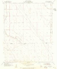
1954 Map of West Camp
USGS Topo · Published 1956About this map
The Kings Co Kern Co boundary bisects this arid landscape, revealing a mid-century infrastructure designed for resource extraction and water management in the southern San Joaquin Valley. At the heart of the district lies West Camp, a small industrial outpost situated near Espy. The terrain is defined by engineered modifications, including a complex network of a Pipe Line, several sections of Levee, and an Abandoned Ditch that suggests shifting irrigation or drainage priorities over time.
Find a feature on this map
13 named features on this map. Tap any name to fly to it.
Don’t see what you’re looking for? This feature index may not catch every label — zoom into the map to look around manually.
Map Details
Editions of this 1954 West Camp Map
3 editions found
Other maps of this area

1914 · Lost Hills
USGS Topo · 1:125,000

1930 · Avenal Gap
USGS Topo · 1:31,680

1930 · Middle Dome
USGS Topo · 1:31,680

1931 · Harvester
USGS Topo · 1:31,680

1932 · Dudley Ridge
USGS Topo · 1:31,680

1932 · Antelope Plain
USGS Topo · 1:31,680

1932 · Reynolds Ranch
USGS Topo · 1:31,680

1932 · West Camp
USGS Topo · 1:31,680

1932 · Lone Tree Well
USGS Topo · 1:31,680

1933 · Avenal Gap
USGS Topo · 1:31,680