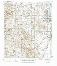
1943 Map of West Carlsbad
USGS Topo · Published 1972About this map
The Pecos River and its western drainage system define this landscape of early 1940s Eddy County, where the desert flats meet the rising Guadalupe Mountains. This map documents a critical era of military and agricultural development, anchored by the Carlsbad Army Air Field and the irrigation infrastructure of Lake Avalon and Spencer Dam. Between the river and the peaks, a network of family ranches—including the Lovejoy Ranch, Denny Ranch, and Miller Ranch—highlights the ranching economy's reliance on scattered water sources like Kee Tank and Thayer Wells.
Find a feature on this map
72 named features on this map. Tap any name to fly to it.
Don’t see what you’re looking for? This feature index may not catch every label — zoom into the map to look around manually.
Map Details
Editions of this 1943 West Carlsbad Map
2 editions found
Other maps of this area

1939 · Carlsbad
USGS Topo · 1:62,500

1940 · Bandanna Point
USGS Topo · 1:62,500

1940 · Carlsbad Caverns West
USGS Topo · 1:62,500

1943 · Carlsbad
USGS Topo · 1:62,500

1943 · Carlsbad Caverns West
USGS Topo · 1:62,500

1943 · Oil City
USGS Topo · 1:62,500

1943 · Bandanna Point
USGS Topo · 1:62,500

1943 · West Carlsbad
USGS Topo · 1:62,500

1945 · West Carlsbad
USGS Topo · 1:62,500

1945 · Carlsbad Caverns East
USGS Topo · 1:62,500