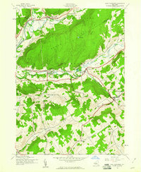
1943 Map of West Davenport
USGS Topo · Published 1970About this map
Charlotte Creek and the Susquehanna River define the physical and economic geography of this 1943 survey, carving deep valleys between the prominent heights of South Hill and Webb Hill. This era captures a landscape transitioning between agricultural roots and the industrial reach of the Delaware and Hudson and New York Central railroads. The valley floor is punctuated by small settlements like West Davenport and Davenport Center, while the surrounding hills remain dotted with one-room schoolhouses, including School No 12 and the Coe Hill Sch.
Find a feature on this map
43 named features on this map. Tap any name to fly to it.
Don’t see what you’re looking for? This feature index may not catch every label — zoom into the map to look around manually.
Map Details
Editions of this 1943 West Davenport Map
3 editions found
Other maps of this area

1907 · Cooperstown
USGS Topo · 1:62,500

1909 · Cooperstown
USGS Topo · 1:62,500

1909 · Delhi
USGS Topo · 1:62,500

1910 · Hartwick
USGS Topo · 1:62,500

1911 · Delhi
USGS Topo · 1:62,500

1912 · Hartwick
USGS Topo · 1:62,500

1915 · Oneonta
USGS Topo · 1:62,500

1918 · Oneonta
USGS Topo · 1:62,500

1943 · Delhi
USGS Topo · 1:24,000

1943 · Mt Vision
USGS Topo · 1:24,000