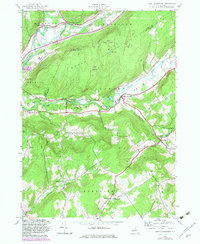
1943 Map of West Davenport
USGS Topo · Published 1983About this map
South Hill and the deep valleys of the Susquehanna River define this corner of the Catskills during the mid-twentieth century. The landscape is a network of small settlements and rural schoolhouses, including School No 12 and the Prosser Hollow Sch, illustrating a decentralized community structure typical of Delaware County before major school consolidations. Transportation is anchored by the Delaware and Hudson railroad tracks running through Cooperstown Junction, while an Old Railroad Grade north of Charlotte Creek hints at earlier transit routes through the valley.
Find a feature on this map
48 named features on this map. Tap any name to fly to it.
Don’t see what you’re looking for? This feature index may not catch every label — zoom into the map to look around manually.
Map Details
Editions of this 1943 West Davenport Map
3 editions found
Other maps of this area

1907 · Cooperstown
USGS Topo · 1:62,500

1909 · Cooperstown
USGS Topo · 1:62,500

1909 · Delhi
USGS Topo · 1:62,500

1910 · Hartwick
USGS Topo · 1:62,500

1911 · Delhi
USGS Topo · 1:62,500

1912 · Hartwick
USGS Topo · 1:62,500

1915 · Oneonta
USGS Topo · 1:62,500

1918 · Oneonta
USGS Topo · 1:62,500

1943 · Delhi
USGS Topo · 1:24,000

1943 · Mt Vision
USGS Topo · 1:24,000