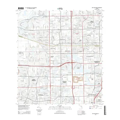
2015 Map of West Dixie Bend
USGS Topo · Published 2015About this map
Hillsboro Canal cuts a distinctive horizontal line across this South Florida landscape, serving as a boundary between Palm Beach and Broward counties. The area is characterized by a dense network of residential developments and planned communities that emerged during the late 20th century, including Sandalfoot Cove, Mission Bay, and Boca Del Mar. Notable landmarks for local history and genealogy include the Eternal Light Memorial Gardens and Forest Lawn Memorial Gardens, alongside educational sites like the Florida Coll of Natural Health. The western edge is defined by the L-40 Canal, where the grid of suburban expansion meets the managed water systems of the Everglades periphery. Smaller enclaves such as West Dixie Bend and Bonnie Loch illustrate the intricate patchwork of incorporated and unincorporated lands that define the modern suburban corridor between Boca Raton and Pompano Beach.
Find a feature on this map
37 named features on this map. Tap any name to fly to it.
Don’t see what you’re looking for? This feature index may not catch every label — zoom into the map to look around manually.
Map Details
Editions of this 2015 West Dixie Bend Map
This is the sole edition of this map. No revisions or reprints were ever made.
Other maps of this area

1945 · Fort Lauderdale North
USGS Topo · 1:24,000

1946 · West Dixie Bend
USGS Topo · 1:24,000

1946 · Boca Raton
USGS Topo · 1:24,000

1947 · Delmar Farms
USGS Topo · 1:24,000

1949 · Fort Lauderdale North
USGS Topo · 1:24,000

1949 · West Dixie Bend
USGS Topo · 1:24,000

1949 · Pompano Beach
USGS Topo · 1:24,000

1949 · Delmar Farms
USGS Topo · 1:24,000

1950 · Boca Raton
USGS Topo · 1:24,000

1950 · Delray Beach
USGS Topo · 1:24,000