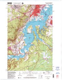
1997 Map of West Duluth
USGS Topo · Published 1999About this map
The industrial and maritime corridors of the St. Louis River waterfront define this area during the late twentieth century. Centered on the Wisconsin Minnesota border, the landscape is shaped by the heavy rail presence of the Duluth Missabe and Iron Range Ry and specialized company-planned neighborhoods like Morgan Park. The map documents the intricate shoreline where St Louis Bay meets the river, featuring landmarks such as Grassy Point and the Bong Bridge connecting Duluth and Superior. Moving south from the city center, established neighborhoods like West Duluth, Gary, and New Duluth transition into the complex wetlands of Spirit Lake and Mud Lake. Educational and civic life is anchored by institutions like Denfeld High Sch and St Josephs Hospital, while the river's winding course is dotted with islands such as Clough Island and Bear Island.
Find a feature on this map
56 named features on this map. Tap any name to fly to it.
Don’t see what you’re looking for? This feature index may not catch every label — zoom into the map to look around manually.
Map Details
Editions of this 1997 West Duluth Map
This is the sole edition of this map. No revisions or reprints were ever made.
Other maps of this area

1895 · Duluth
USGS Topo · 1:62,500

1915 · Superior
USGS Topo · 1:48,000

1917 · Superior
USGS Topo · 1:62,500

1953 · Adolph
USGS Topo · 1:24,000

1953 · Duluth
USGS Topo · 1:24,000

1953 · Duluth Heights
USGS Topo · 1:24,000

1953 · Duluth
USGS Topo · 1:62,500

1953 · Duluth
USGS Topo · 1:250,000

1954 · West Duluth
USGS Topo · 1:24,000

1954 · Borea
USGS Topo · 1:24,000