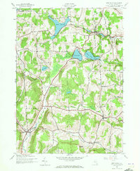
1943 Map of West Eaton
USGS Topo · Published 1973About this map
The Eaton Reservoir and Bradley Brook Reservoir define the high-country hydrology of central New York during the early 1940s. Situated at the intersections of the towns of Nelson, Eaton, Georgetown, and Lebanon, this landscape is marked by a network of rural hamlets and small industrial outposts. The map records the local infrastructure of the era, from the educational hub at School No 1 to the resting place at Hillside Cem. In the valley, the Otselic River and Lebanon Brook dictate the placement of early road corridors and settlements. Genealogical details are found at named peaks like Dunhams Pinnacle and Niles Gems, while the presence of Georgetown Sta hints at the community's historical reliance on the rail network that once serviced the dairy and agricultural heartland of Madison County.
Find a feature on this map
27 named features on this map. Tap any name to fly to it.
Don’t see what you’re looking for? This feature index may not catch every label — zoom into the map to look around manually.
Map Details
Editions of this 1943 West Eaton Map
2 editions found
Other maps of this area

1897 · Cazenovia
USGS Topo · 1:62,500

1899 · Cazenovia
USGS Topo · 1:62,500

1902 · Morrisville
USGS Topo · 1:62,500

1903 · Norwich
USGS Topo · 1:62,500

1904 · Pitcher
USGS Topo · 1:62,500

1943 · Otselic
USGS Topo · 1:24,000
1943 · Cazenovia
USGS Topo · 1:24,000

1943 · West Eaton
USGS Topo · 1:24,000

1943 · Morrisville
USGS Topo · 1:24,000

1943 · South Ostelic
USGS Topo · 1:24,000