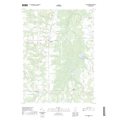
2023 Map of West Farmington
USGS Topo · Published 2023About this map
The Grand River and its intricate network of tributaries, including Swine Creek and Dead Run, define this Trumbull County landscape. Centered on the crossroads of Mesopotamia, the map illustrates a rural settlement pattern where agricultural tracts are punctuated by historic burial grounds such as Fairview Cem and Clark Cem. To the south, the village of West Farmington sits near Hillside Cem, while East Farmington is situated along Greenville Rd NW. The presence of the Bristol Airstrip and numerous small water bodies like Coppedge Pond suggests a mix of local aviation and managed water resources. This survey provides a clear view of the area's transition from open fields to the wooded corridors of Coffee Creek and Baughman Creek, tracing the enduring road networks that connect these small Ohio communities.
Find a feature on this map
63 named features on this map. Tap any name to fly to it.
Don’t see what you’re looking for? This feature index may not catch every label — zoom into the map to look around manually.
Map Details
Editions of this 2023 West Farmington Map
This is the sole edition of this map. No revisions or reprints were ever made.
Other maps of this area

1904 · Chardon
USGS Topo · 1:62,500

1905 · Bristolville
USGS Topo · 1:62,500

1905 · Garrettsville
USGS Topo · 1:62,500

1905 · Jefferson
USGS Topo · 1:62,500

1906 · Chardon
USGS Topo · 1:62,500

1907 · Bristolville
USGS Topo · 1:62,500

1907 · Jefferson
USGS Topo · 1:62,500

1907 · Garrettsville
USGS Topo · 1:62,500

1950 · Cleveland
USGS Topo · 1:250,000

1952 · West Farmington
USGS Topo · 1:24,000
Featured Places
- Mesopotamia Township, OH
- Mesopotamia, Mesopotamia Township
- Farmington Township, OH
- Farmington, Farmington Township
- Bloomfield Township, OH