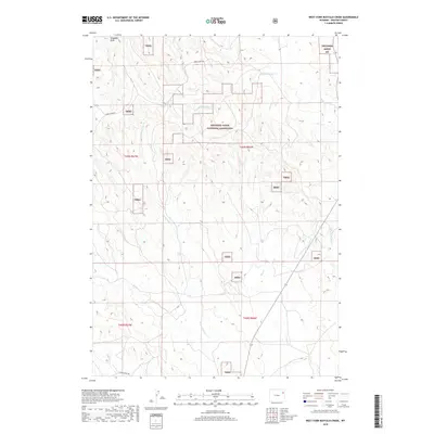
2018 Map of West Fork Buffalo Creek
USGS Topo · Published 2018About this map
Thunder Basin National Grassland dominates this section of Weston County, providing a detailed look at the complex grid of public and private lands in the Wyoming High Plains. The landscape is defined by the headwaters of several drainage systems, most notably W Fork Buffalo Cr and Buffalo Cr in the north, which cut through the undulating terrain near Schoeber Draw. Further south, the map traces the upper reaches of W Fork Hay Cr, Hay Cr, and E Fork Hay Cr. These waterways create a distinct north-south drainage pattern that has historically shaped ranching and grazing boundaries in this part of the Thunder Basin. The layout of Raven Creek Rd and various section lines within t46n r66w and adjacent townships illustrates the rural infrastructure supporting the region's agricultural and energy-rich character.
Find a feature on this map
14 named features on this map. Tap any name to fly to it.
Don’t see what you’re looking for? This feature index may not catch every label — zoom into the map to look around manually.
Map Details
Editions of this 2018 West Fork Buffalo Creek Map
This is the sole edition of this map. No revisions or reprints were ever made.
Other maps of this area

1918 · Moorcroft
USGS Topo · 1:125,000

1954 · Gillette
USGS Topo · 1:250,000

1955 · Newcastle
USGS Topo · 1:250,000

1955 · Gillette
USGS Topo · 1:250,000

1957 · Upton
USGS Topo · 1:62,500

1958 · Gillette
USGS Topo · 1:250,000

1958 · Newcastle
USGS Topo · 1:250,000

1962 · Gillette
USGS Topo · 1:250,000

1979 · Newcastle
USGS Topo · 1:100,000

1979 · Sundance
USGS Topo · 1:100,000