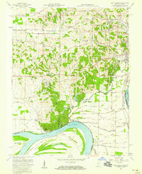
1957 Map of West Franklin
USGS Topo · Published 1965About this map
The wide, sweeping arc of the Ohio River dominates the southern portion of this landscape, defining the boundary between Indiana and Kentucky at Cypress Bend. To the north, the terrain transitions into a dense network of rural infrastructure centered around the small settlement of West Franklin. The map reveals a mid-century community supported by numerous small institutions, from the Corpus Christi Sch and Perry Heights Sch in the east to St Pauls Ch in the west. Local transportation is anchored by the Louisville And Nashville Railroad, which cuts through the northern hills near Belknap. Notable landmarks such as Boehne Hospital and several family-named roads like Vickery Road and Duesner Road provide a granular view of the county's social and geographic layout before modern suburban expansion significantly altered the area.
Find a feature on this map
64 named features on this map. Tap any name to fly to it.
Don’t see what you’re looking for? This feature index may not catch every label — zoom into the map to look around manually.
Map Details
Editions of this 1957 West Franklin Map
2 editions found
Other maps of this area

1901 · Haubstadt
USGS Topo · 1:62,500

1903 · Haubstadt
USGS Topo · 1:62,500

1903 · New Harmony
USGS Topo · 1:62,500

1903 · Patoka
USGS Topo · 1:125,000

1914 · Henderson
USGS Topo · 1:48,000

1916 · Henderson
USGS Topo · 1:62,500

1917 · Uniontown
USGS Topo · 1:62,500

1938 · New Harmony
USGS Topo · 1:62,500

1952 · Evansville
USGS Topo · 1:24,000
1952 · Henderson
USGS Topo · 1:24,000