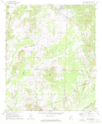
1970 Map of West Greene
USGS Topo · Published 1972About this map
The St Stephens Meridian serves as a primary geographic anchor for this rural landscape in western Greene County. Small settlements such as West Greene, Clinton, and Mt Hebron are connected by a network of local roads and watercourses like Wilkes Creek and Trussells Creek. The terrain is characterized by numerous family and community landmarks, including the Eatman Cem and Zion Hill Ch. An Old Railroad Grade winds through the northern sections, while the active St Louis-San Francisco Railroad cuts across the southern portion of the quadrangle. These features, alongside the Radio Tower and various branches like Bangdoodle Branch, reflect a mid-century agricultural and transit-oriented infrastructure. For researchers, the density of small churches such as New Light Ch and Sardis Ch provides significant points of interest for tracing community development and local genealogy.
Find a feature on this map
34 named features on this map. Tap any name to fly to it.
Don’t see what you’re looking for? This feature index may not catch every label — zoom into the map to look around manually.
Map Details
Editions of this 1970 West Greene Map
This is the sole edition of this map. No revisions or reprints were ever made.
Other maps of this area

1927 · Eutaw
USGS Topo · 1:48,000

1931 · Eutaw
USGS Topo · 1:62,500

1953 · Montgomery
USGS Topo · 1:250,000

1953 · Birmingham
USGS Topo · 1:250,000

1953 · Meridian
USGS Topo · 1:250,000

1953 · West Point
USGS Topo · 1:250,000

1956 · Birmingham
USGS Topo · 1:250,000

1956 · Montgomery
USGS Topo · 1:250,000

1957 · Birmingham
USGS Topo · 1:250,000

1957 · Meridian
USGS Topo · 1:250,000