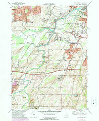
1971 Map of West Henrietta
USGS Topo · Published 1978About this map
The Genesee River carves a serpentine path through this landscape, marking the transition from the urban periphery of Rochester to the rural townships of Henrietta and Rush. In the north, the expanding campus of the Rochester Institute of Technology and proximity to the Rochester Monroe Co Airport signal the area's mid-century suburbanization. This growth contrasts with the established agricultural character farther south, where long-standing family landmarks like Bushman Cem and the small settlement of Martin persist.
Find a feature on this map
82 named features on this map. Tap any name to fly to it.
Don’t see what you’re looking for? This feature index may not catch every label — zoom into the map to look around manually.
Map Details
Editions of this 1971 West Henrietta Map
2 editions found
Other maps of this area

1895 · Rochester
USGS Topo · 1:62,500

1898 · Rochester
USGS Topo · 1:62,500

1899 · Brockport
USGS Topo · 1:62,500

1901 · Honeoye
USGS Topo · 1:62,500

1904 · Caledonia
USGS Topo · 1:62,500

1904 · Honeoye
USGS Topo · 1:62,500

1912 · Rochester
USGS Topo · 1:62,500

1920 · Rochester
USGS Topo · 1:62,500

1931 · Mendon Ponds
USGS Topo · 1:24,000

1931 · Rochester West
USGS Topo · 1:24,000