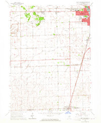
1964 Map of West Kankakee
USGS Topo · Published 1965About this map
The industrial and agricultural outskirts of the Kankakee area are detailed in this mid-1960s survey, showing the expansion of West Kankakee near the New York Central tracks. The map illustrates a landscape transitioning from the urban core of Kankakee to the flat farmland of the Otto and Chebanse townships. Key local infrastructure is present, including the Kankakee Airport and several industrial sites such as a large western Quarry and various sandpits.
Find a feature on this map
23 named features on this map. Tap any name to fly to it.
Don’t see what you’re looking for? This feature index may not catch every label — zoom into the map to look around manually.
Map Details
Editions of this 1964 West Kankakee Map
3 editions found
Other maps of this area

1922 · Kankakee
USGS Topo · 1:62,500

1923 · Herscher
USGS Topo · 1:62,500

1924 · Kankakee
USGS Topo · 1:62,500

1925 · Herscher
USGS Topo · 1:62,500

1944 · Piper City
USGS Topo · 1:48,000

1944 · Gilman
USGS Topo · 1:62,500

1946 · Gilman
USGS Topo · 1:62,500

1947 · Piper City
USGS Topo · 1:62,500

1953 · Chicago
USGS Topo · 1:250,000

1953 · Danville
USGS Topo · 1:250,000