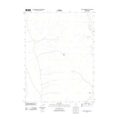
2012 Map of West Morris Basin
USGS Topo · Published 2012About this map
West Morris Basin and the adjacent Morris Basin define this section of Elko County, Nevada, as captured in this 2012 US Topo sheet. The landscape is marked by a network of intermittent stream channels and drainage paths that converge toward these low-lying basin areas. Evidence of water in this arid high-desert environment is highlighted by Tunnel Spring, a localized water source in the central eastern portion of the quadrangle. The map details a sparse infrastructure of unpaved roads and tracks that navigate the terrain between these natural depressions, illustrating the isolation and open character of the region during the early 21st century.
Find a feature on this map
3 named features on this map. Tap any name to fly to it.
Don’t see what you’re looking for? This feature index may not catch every label — zoom into the map to look around manually.
Map Details
Editions of this 2012 West Morris Basin Map
This is the sole edition of this map. No revisions or reprints were ever made.
Other maps of this area

1955 · Elko
USGS Topo · 1:250,000

1958 · Elko
USGS Topo · 1:250,000

1962 · Elko
USGS Topo · 1:250,000

1965 · Elko
USGS Topo · 1:250,000
1971 · Hardy Creek
USGS Topo · 1:24,000

1971 · West Morris Basin
USGS Topo · 1:24,000
1971 · Silver Zone Pass
USGS Topo · 1:24,000

1971 · Shafter
USGS Topo · 1:24,000

1971 · Pilot
USGS Topo · 1:24,000
1971 · Leppy Peak NW
USGS Topo · 1:24,000