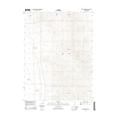
2015 Map of West Morris Basin
USGS Topo · Published 2015About this map
The Toano Range dominates this corner of Elko County, rising between the expansive desert sinks of the Goshute Valley and the smaller, high-elevation basins to the east. This 2015 survey highlights the stark divide of the Great Basin terrain, where the ridge lines of the range separate the Silver Zone Basin from the West Morris Basin. Water remains the primary constraint and landmark in this arid environment, evidenced by the presence of Tunnel Spring tucked into the eastern slopes. The map traces the intricate drainage patterns that define the Morris Basin area, where seasonal runoff from the surrounding peaks shapes the valley floors. These topographic details illustrate the vast, unpopulated character of the Nevada interior, where land use is primarily defined by the Public Land Survey System boundaries across multiple townships.
Find a feature on this map
12 named features on this map. Tap any name to fly to it.
Don’t see what you’re looking for? This feature index may not catch every label — zoom into the map to look around manually.
Map Details
Editions of this 2015 West Morris Basin Map
This is the sole edition of this map. No revisions or reprints were ever made.
Other maps of this area

1955 · Elko
USGS Topo · 1:250,000

1958 · Elko
USGS Topo · 1:250,000

1962 · Elko
USGS Topo · 1:250,000

1965 · Elko
USGS Topo · 1:250,000
1971 · Hardy Creek
USGS Topo · 1:24,000

1971 · West Morris Basin
USGS Topo · 1:24,000
1971 · Silver Zone Pass
USGS Topo · 1:24,000

1971 · Shafter
USGS Topo · 1:24,000

1971 · Pilot
USGS Topo · 1:24,000
1971 · Leppy Peak NW
USGS Topo · 1:24,000