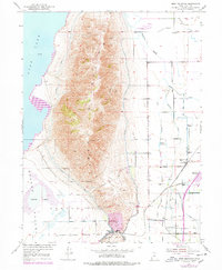
1950 Map of West Mountain
USGS Topo · Published 1978About this map
West Mountain dominates this mid-century landscape, acting as a massive geographical barrier between the southern reaches of Utah Lake and the industrial activity of the Goshen Valley. The southeastern foothills reveal a hub of resource extraction and transit centered around the Keigley Quarry and the settlement of Keigley. This area serves as a vital corridor where the Denver and Rio Grande Western and Pacific railroads converge, facilitating the movement of materials from local Gravel Pits toward larger markets. To the west, the town of Genola sits near the edge of White Lake, while the eastern plains are defined by complex water management systems like the Benjamin Slough, Beer Creek, and the Tanner Reservoir. The map illustrates a period of industrial infrastructure development balanced against the natural springs and creeks of the Utah Valley.
Find a feature on this map
27 named features on this map. Tap any name to fly to it.
Don’t see what you’re looking for? This feature index may not catch every label — zoom into the map to look around manually.
Map Details
Editions of this 1950 West Mountain Map
3 editions found
Other maps of this area

1885 · Salt Lake
USGS Topo · 1:250,000

1885 · Manti
USGS Topo · 1:250,000

1895 · Manti
USGS Topo · 1:250,000

1948 · Spanish Fork
USGS Topo · 1:24,000

1948 · Provo
USGS Topo · 1:24,000

1949 · Provo
USGS Topo · 1:62,500

1950 · Provo
USGS Topo · 1:24,000

1950 · Spanish Fork
USGS Topo · 1:24,000

1950 · West Mountain
USGS Topo · 1:24,000
1950 · Goshen Valley North
USGS Topo · 1:24,000