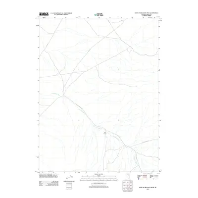
2012 Map of West of Bellevue Peak
USGS Topo · Published 2012About this map
Fenstermaker Wash defines the drainage pattern of this high desert landscape in Eureka County, cutting northwest through the center of the sheet towards the valley floor. The terrain is marked by the rugged incision of Davis Canyon in the southern portion, where the elevation begins to rise. A network of rural corridors and ranch roads provides access to this isolated area, including Spring Vly and Ardan Wl. The name Fish Creek-Ardan Rnch suggests the long-standing livestock and ranching history typical of central Nevada's basin and range province. These roads likely served remote outposts and water sources for cattle operations, as indicated by labels such as Mile Wl and the crossing at Cockalorum.
Find a feature on this map
7 named features on this map. Tap any name to fly to it.
Don’t see what you’re looking for? This feature index may not catch every label — zoom into the map to look around manually.
Map Details
Editions of this 2012 West of Bellevue Peak Map
This is the sole edition of this map. No revisions or reprints were ever made.
Other maps of this area

1926 · Roberts Mountains
USGS Topo · 1:250,000

1929 · Roberts Mountains
USGS Topo · 1:250,000

1955 · Millett
USGS Topo · 1:250,000

1956 · Bellevue Peak
USGS Topo · 1:62,500

1956 · Cockalorum Wash
USGS Topo · 1:62,500

1956 · Horse Heaven Mtn
USGS Topo · 1:62,500

1956 · Antelope Peak
USGS Topo · 1:62,500

1959 · Millett
USGS Topo · 1:250,000

1978 · Summit Mountain
USGS Topo · 1:100,000
1989 · Ninemile Peak
USGS Topo · 1:24,000