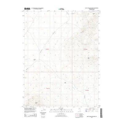
2014 Map of West of Bellevue Peak
USGS Topo · Published 2014About this map
Antelope Valley serves as the central basin of this Great Basin landscape, flanked by the elevated terrain of the Antelope Range to the southwest and the Fish Creek Range to the east. This 2014 survey captures a section of Eureka County defined by dry washes and canyon systems, most notably Fenstermaker Wash which drains through the center of the quadrangle. High-altitude landmarks like the Mahogany Hills and the secluded Davis Canyon illustrate the topographical variation of this high-desert environment.
Find a feature on this map
14 named features on this map. Tap any name to fly to it.
Don’t see what you’re looking for? This feature index may not catch every label — zoom into the map to look around manually.
Map Details
Editions of this 2014 West of Bellevue Peak Map
This is the sole edition of this map. No revisions or reprints were ever made.
Other maps of this area

1926 · Roberts Mountains
USGS Topo · 1:250,000

1929 · Roberts Mountains
USGS Topo · 1:250,000

1955 · Millett
USGS Topo · 1:250,000

1956 · Bellevue Peak
USGS Topo · 1:62,500

1956 · Cockalorum Wash
USGS Topo · 1:62,500

1956 · Horse Heaven Mtn
USGS Topo · 1:62,500

1956 · Antelope Peak
USGS Topo · 1:62,500

1959 · Millett
USGS Topo · 1:250,000

1978 · Summit Mountain
USGS Topo · 1:100,000
1989 · Ninemile Peak
USGS Topo · 1:24,000