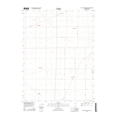
2014 Map of West of Christina Peak
USGS Topo · Published 2014About this map
Diamond Valley occupies this high desert landscape, characterized by a structured grid of rural roads and section lines established by the Public Land Survey System. The area reflects a transitional landscape where historic ranching routes like Sulfur Thompson Rd and Cottonwood Ranch Rd meet a more modern, formalized network of numbered and named streets such as 15th St and Keg St. The map illustrates the expansive nature of Basin and Range topography in Nevada, showing the vast open spaces between the Diamond Mountains to the east and the Roberts Creek Mountains to the west. This 2014 survey documents the persistence of the rural agricultural and ranching layout, with the inclusion of arterial routes like Co Road 1 and Mustang Rd serving as the primary infrastructure connecting remote land parcels.
Find a feature on this map
20 named features on this map. Tap any name to fly to it.
Don’t see what you’re looking for? This feature index may not catch every label — zoom into the map to look around manually.
Map Details
Editions of this 2014 West of Christina Peak Map
This is the sole edition of this map. No revisions or reprints were ever made.
Other maps of this area

1926 · Roberts Mountains
USGS Topo · 1:250,000

1929 · Roberts Mountains
USGS Topo · 1:250,000

1949 · Garden Valley
USGS Topo · 1:62,500

1951 · Garden Valley
USGS Topo · 1:62,500

1953 · Eureka
USGS Topo · 1:62,500

1955 · Millett
USGS Topo · 1:250,000

1956 · Whistler Mtn
USGS Topo · 1:62,500

1956 · Ely
USGS Topo · 1:250,000

1957 · Diamond Springs
USGS Topo · 1:62,500

1959 · Ely
USGS Topo · 1:250,000