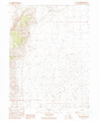
1990 Map of West of Empire
USGS Topo · Published 1990About this map
The Black Rock Desert dominates the eastern landscape of this 1990 provisional survey, where the arid basin meets the eastern slopes of the Fox Range. This region of Washoe County reflects a rugged, high-desert environment defined by seasonal hydrology and resource exploration. Scattered across the alluvial fans and playa margins are evidence of human activity, including a solitary Windmill and a marked Prospect, indicating the persistent search for minerals or water in an unforgiving climate.
Find a feature on this map
10 named features on this map. Tap any name to fly to it.
Don’t see what you’re looking for? This feature index may not catch every label — zoom into the map to look around manually.
Map Details
Editions of this 1990 West of Empire Map
This is the sole edition of this map. No revisions or reprints were ever made.
Other maps of this area

1886 · Granite Range
USGS Topo · 1:250,000

1894 · Granite Range
USGS Topo · 1:250,000

1955 · Lovelock
USGS Topo · 1:250,000

1959 · Lovelock
USGS Topo · 1:250,000

1964 · Gerlach
USGS Topo · 1:62,500

1964 · Kumiva Peak
USGS Topo · 1:62,500

1965 · Fox Range
USGS Topo · 1:62,500

1980 · Wall Spring
USGS Topo · 1:24,000

1980 · Smith Canyon
USGS Topo · 1:24,000

1981 · Gerlach
USGS Topo · 1:100,000