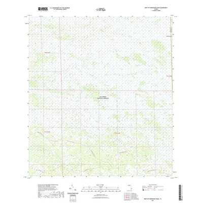
2021 Map of West of Horseshoe Head
USGS Topo · Published 2021About this map
Big Cypress National Preserve dominates this section of the Florida landscape, representing a critical area of protected wetlands along the border of Collier and Broward Counties. The map detail reveals the intricate seasonal hydrology of The Everglades, where a subtle network of backcountry routes provides the only passage through the water-logged terrain. Human presence is limited to specialized paths such as Raccoon Point Cdu Trl and North Raccoon Point Trl, which navigate the northern reaches of the Raccoon Point region. These tracks, along with Lost Dog 1 Trl, illustrate the minimal development within this vast conservation area, where the environment remains defined by natural drainage patterns rather than permanent settlements or paved infrastructure.
Find a feature on this map
11 named features on this map. Tap any name to fly to it.
Don’t see what you’re looking for? This feature index may not catch every label — zoom into the map to look around manually.
Map Details
Editions of this 2021 West of Horseshoe Head Map
This is the sole edition of this map. No revisions or reprints were ever made.
Other maps of this area

1956 · Miami
USGS Topo · 1:250,000

1956 · West Palm Beach
USGS Topo · 1:250,000

1957 · West Palm Beach
USGS Topo · 1:250,000

1958 · West Palm Beach
USGS Topo · 1:250,000

1958 · Miami
USGS Topo · 1:250,000

1972 · Monroe Station NE
USGS Topo · 1:24,000

1973 · North Of Fiftymile Bend
USGS Topo · 1:24,000

1973 · Everglades 3 NE
USGS Topo · 1:24,000
1973 · North of Fortymile Bend
USGS Topo · 1:24,000
1974 · Everglades 3 SW
USGS Topo · 1:24,000