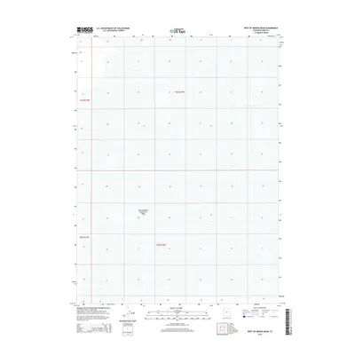
2014 Map of West of Miners Basin
USGS Topo · Published 2014About this map
Newfoundland Evaporation Basin dominates the center of this landscape in Box Elder County, illustrating the industrial use of Utah's salt flats. This 2014 survey focuses on the vast, low-lying terrain west of the Newfoundland Mountains, where the grid of the Public Land Survey System defines the organization of space across T6N R15W and T5N R15W. The map captures the stark geometry of evaporation ponds and the infrastructure required to manage saline resources in this arid environment.
Find a feature on this map
5 named features on this map. Tap any name to fly to it.
Don’t see what you’re looking for? This feature index may not catch every label — zoom into the map to look around manually.
Map Details
Editions of this 2014 West of Miners Basin Map
This is the sole edition of this map. No revisions or reprints were ever made.
Other maps of this area

1954 · Brigham City
USGS Topo · 1:250,000

1958 · Brigham City
USGS Topo · 1:250,000

1962 · Brigham City
USGS Topo · 1:250,000

1983 · Jackson
USGS Topo · 1:24,000

1983 · Lemay
USGS Topo · 1:24,000
1983 · Lucin 4 SW
USGS Topo · 1:24,000

1983 · Bovine SE
USGS Topo · 1:24,000
1983 · Big Pass
USGS Topo · 1:24,000

1983 · Lucin 4 NE
USGS Topo · 1:24,000
1983 · Miners Basin
USGS Topo · 1:24,000