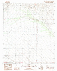
1988 Map of West of Palo Verde Peak
USGS Topo · Published 1988About this map
Smoketree Valley and the vast desert drainage of Milpitas Wash dominate this arid landscape in eastern Imperial County. The terrain is defined by a sparse network of 4wd tracks and several remote mining excavations, each marked simply as Prospect, indicating a history of exploration in these dry highlands. The southern half of the quadrangle is largely occupied by the Chocolate Mountain Aerial Gunnery Range, with the Chocolate Mountain Aerial Gunnery Range Boundary cutting through the desert flats. This 1988 provisional survey provides a precise look at the land use and accessibility of this restricted military and mineral-rich zone during the late twentieth century.
Find a feature on this map
9 named features on this map. Tap any name to fly to it.
Don’t see what you’re looking for? This feature index may not catch every label — zoom into the map to look around manually.
Map Details
Editions of this 1988 West of Palo Verde Peak Map
This is the sole edition of this map. No revisions or reprints were ever made.
Other maps of this area

1942 · Blythe
USGS Topo · 1:250,000

1953 · Palo Verde Mountains
USGS Topo · 1:62,500

1953 · Quartz Peak
USGS Topo · 1:62,500

1953 · Chuckwalla Spring
USGS Topo · 1:62,500

1953 · Acolita
USGS Topo · 1:62,500

1954 · Salton Sea
USGS Topo · 1:250,000

1955 · Salton Sea
USGS Topo · 1:250,000

1959 · Salton Sea
USGS Topo · 1:250,000

1963 · Salton Sea
USGS Topo · 1:250,000

1965 · Salton Sea
USGS Topo · 1:250,000