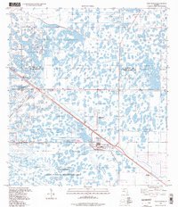
1994 Map of West Of Rood
USGS Topo · Published 1998About this map
The J W Corbett State Wildlife Management Area dominates this section of the Florida landscape, representing a vast expanse of wetlands and managed conservation land across the Martin Co Palm Beach Co line. The map reveals the infrastructure required to support the growing interior of South Florida, featuring a prominent Pipeline, multiple instances of Sewage Disposal, and a Filtration Plant with accompanying Wells. Transport and recreation appear in the form of a Landing Strip and the Palm Beach Raceway, located near the settlement of United. Further north along the diagonal rail or road corridor, the locality of Apix marks a specific point of human activity within an otherwise water-logged terrain of cypress heads and marshes.
Find a feature on this map
13 named features on this map. Tap any name to fly to it.
Don’t see what you’re looking for? This feature index may not catch every label — zoom into the map to look around manually.
Map Details
Editions of this 1994 West Of Rood Map
This is the sole edition of this map. No revisions or reprints were ever made.
Other maps of this area

1945 · Delta
USGS Topo · 1:24,000

1948 · Rood
USGS Topo · 1:24,000

1948 · Gomez
USGS Topo · 1:24,000

1949 · Rood
USGS Topo · 1:24,000

1949 · Gomez
USGS Topo · 1:24,000

1950 · Delta
USGS Topo · 1:24,000

1953 · Indian Town SE
USGS Topo · 1:24,000

1953 · Indian Town
USGS Topo · 1:24,000

1956 · West Palm Beach
USGS Topo · 1:250,000

1956 · Fort Pierce
USGS Topo · 1:250,000