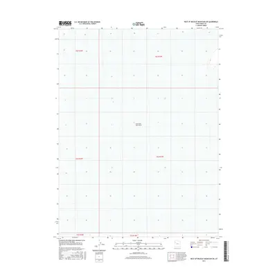
2017 Map of West of Wildcat Mountain SW
USGS Topo · Published 2017About this map
Great Salt Lake Desert dominates this Tooele County landscape, presenting a stark expanse defined by the vast remnants of an ancient lakebed. The geography is characterized by its extreme flatness and the absence of traditional landmarks or settlements, with the map serving primarily as a study in land division across the salt flats. Surveyed by the U.S. Geological Survey, the grid system of sections and townships—including t5s r16w, t5s r15w, t6s r16w, and t6s r15w—provides the only structural framework over this desolate terrain. This 2017 study illustrates the enduring emptiness of the region, where the lack of roads or water features reflects the challenging environmental conditions of the interior basin.
Find a feature on this map
7 named features on this map. Tap any name to fly to it.
Don’t see what you’re looking for? This feature index may not catch every label — zoom into the map to look around manually.
Map Details
Editions of this 2017 West of Wildcat Mountain SW Map
This is the sole edition of this map. No revisions or reprints were ever made.
Other maps of this area

1953 · Tooele
USGS Topo · 1:250,000

1955 · Tooele
USGS Topo · 1:250,000

1973 · Wildcat Mountain SW
USGS Topo · 1:24,000

1973 · Wildcat Mountain NW
USGS Topo · 1:24,000

1973 · Gold Hill 1 SE
USGS Topo · 1:24,000

1973 · Gold Hill 1 SW
USGS Topo · 1:24,000

1973 · Gold Hill 1 NE
USGS Topo · 1:24,000

1973 · Granite Peak NW
USGS Topo · 1:24,000
1973 · Gold Hill 4 NE
USGS Topo · 1:24,000
1973 · Gold Hill Wash
USGS Topo · 1:24,000