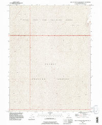
1993 Map of West of Wildcat Mountain SW
USGS Topo · Published 1996About this map
The Dugway Proving Ground defines this expanse of the Great Salt Lake Desert in Tooele County. Established as a military test site during the mid-20th century, the landscape is characterized by its extreme isolation and the extensive Mud Flat terrain that dominates the topography. This 1993 revision, based on imagery dating back to 1973, shows the intersection of the Utah Test and Training Range with the proving ground, highlighting a region dedicated almost exclusively to national defense operations and specialized environmental testing. The map reveals the stark nature of the landscape where wide alkaline basins meet the fringes of the surrounding mountains, providing a precise look at the land use and military boundaries in one of the most remote parts of the American West.
Find a feature on this map
6 named features on this map. Tap any name to fly to it.
Don’t see what you’re looking for? This feature index may not catch every label — zoom into the map to look around manually.
Map Details
Editions of this 1993 West of Wildcat Mountain SW Map
This is the sole edition of this map. No revisions or reprints were ever made.
Other maps of this area

1953 · Tooele
USGS Topo · 1:250,000

1955 · Tooele
USGS Topo · 1:250,000

1973 · Wildcat Mountain SW
USGS Topo · 1:24,000

1973 · Wildcat Mountain NW
USGS Topo · 1:24,000

1973 · Gold Hill 1 SE
USGS Topo · 1:24,000

1973 · Gold Hill 1 SW
USGS Topo · 1:24,000

1973 · Gold Hill 1 NE
USGS Topo · 1:24,000

1973 · Granite Peak NW
USGS Topo · 1:24,000
1973 · Gold Hill 4 NE
USGS Topo · 1:24,000
1973 · Gold Hill Wash
USGS Topo · 1:24,000