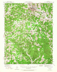
1944 Map of West Plains
USGS Topo · Published 1967About this map
West Plains serves as the focal point of this Ozark region, situated at the junction of the St Louis - San Francisco railroad. The 1940s landscape is densely marked by a network of rural schoolhouses and neighborhood churches, reflecting the localized social structure of Howell County before school consolidation. Notable institutions include the County Home and American Legion Field on the outskirts of the main settlement. Further south, the terrain follows the South Fork Spring River toward the Missouri-Arkansas border, where small crossroads like Moody and Lanton anchor the rural community. Genealogists will find significant value in the distribution of family-named landmarks and cemeteries, such as the Saddle Cem and Mc Elmerry Cem, which pinpoint early local burial sites and homesteads often missed by broader regional histories.
Find a feature on this map
52 named features on this map. Tap any name to fly to it.
Don’t see what you’re looking for? This feature index may not catch every label — zoom into the map to look around manually.
Map Details
Editions of this 1944 West Plains Map
2 editions found
Other maps of this area

1890 · Mountain Home
USGS Topo · 1:125,000

1891 · Mountain Home
USGS Topo · 1:125,000

1894 · Mountain Home
USGS Topo · 1:125,000

1938 · West Plains
USGS Topo · 1:24,000

1939 · Topaz
USGS Topo · 1:62,500

1940 · West Plains
USGS Topo · 1:24,000

1941 · Topaz
USGS Topo · 1:62,500

1943 · Thayer
USGS Topo · 1:62,500

1944 · West Plains
USGS Topo · 1:62,500

1944 · Cureall
USGS Topo · 1:62,500