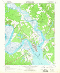
1965 Map of West Point
USGS Topo · Published 1968About this map
West Point stands as a pivotal river hub at the confluence of the Mattaponi River and Pamunkey River, where they merge to form the wide York River. This mid-1960s landscape is defined by its deep-water connections and the presence of the Southern Railway, which terminates at the tip of the peninsula. The map reveals a community structured around its waterfront, with residential and commercial blocks in the town center transitioning to industrial sites like the Sewage Disposal and the nearby Port Richmond.
Find a feature on this map
73 named features on this map. Tap any name to fly to it.
Don’t see what you’re looking for? This feature index may not catch every label — zoom into the map to look around manually.
Map Details
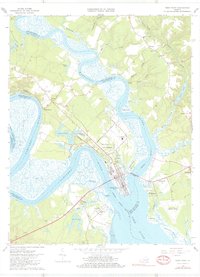
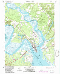
Editions of this 1965 West Point Map
3 editions found
Other maps of this area

1906 · Williamsburg
USGS Topo · 1:62,500

1917 · Urbanna
USGS Topo · 1:62,500

1917 · Toano
USGS Topo · 1:62,500

1918 · Toano
USGS Topo · 1:62,500

1919 · New Kent
USGS Topo · 1:62,500

1943 · Richmond
USGS Topo · 1:250,000

1949 · Truhart
USGS Topo · 1:24,000

1949 · Shacklefords
USGS Topo · 1:24,000

1949 · King And Queen
USGS Topo · 1:24,000
1949 · Samos
USGS Topo · 1:24,000