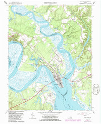
1965 Map of West Point
USGS Topo · Published 1986About this map
Mattaponi River and the Pamunkey River converge at the tip of the Virginia Peninsula to form the broad York River, a geographic centerpiece that has defined the growth of West Point. This mid-1960s survey captures the town at a strategic transport junction, where the Southern railroad terminus meets the tidewater. The map detail highlights a well-developed community infrastructure including West Point High School, the West Point Country Club, and various civic sites like the Sunny Slope Cemetery and St. Theresa Cemetery. Beyond the urban center, the landscape is a mosaic of tidal marshes like Lee Marsh and smaller settlements such as Port Richmond, Eltham, and Shanghai. The transition from rural land use to industrial activity is evident in the presence of scattered sandpits and the West Point Municipal Airport, while numerous family-named landings like Waterfence Landing and Ryefield Landing speak to a long-standing relationship with the surrounding waterways.
Find a feature on this map
63 named features on this map. Tap any name to fly to it.
Don’t see what you’re looking for? This feature index may not catch every label — zoom into the map to look around manually.
Map Details
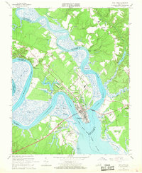
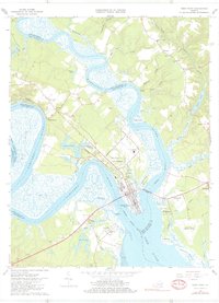
Editions of this 1965 West Point Map
3 editions found
Other maps of this area

1906 · Williamsburg
USGS Topo · 1:62,500

1917 · Urbanna
USGS Topo · 1:62,500

1917 · Toano
USGS Topo · 1:62,500

1918 · Toano
USGS Topo · 1:62,500

1919 · New Kent
USGS Topo · 1:62,500

1943 · Richmond
USGS Topo · 1:250,000

1949 · Truhart
USGS Topo · 1:24,000

1949 · Shacklefords
USGS Topo · 1:24,000

1949 · King And Queen
USGS Topo · 1:24,000
1949 · Samos
USGS Topo · 1:24,000